


Introduction
Floods are one of the costliest natural hazards, they affect natural and built environment, people and infrastructures causing severe losses. In 2016, losses caused by hydrological events were 36 bn US$ (Munich Re, 2017). Flood hazard is the probability of occurrence of an event at a certain location and is a crucial information for land-use planners and decision makers. With the 60/2007/EC Directive, entered into force on 26 November 2007, a new framework has been set up with the aim of reducing and managing the risks that floods pose to human health, the environment, cultural heritage and economic activity.
This Directive now requires Member States to assess if all water courses and coast lines are at risk from flooding, to map the flood extent and assets and humans at risk in these areas and to take adequate and coordinated measures to reduce this flood risk. This Directive also reinforces the rights of the public to access this information and to have a say in the planning process.
An effective flood risk assessment requires the estimation of its three components: hazard, exposure and vulnerability (Fig. 1). Exposure measures the number and value of elements located in a flood-prone area (e.g. number of buildings, people etc.). Vulnerability measures the expected degree of loss for a given hazard parameter (e.g. flood depth).
Depending on the target and on the scale of analysis the complexity of such an estimate may vary significantly due to (i) modelling approaches, (ii) desired spatial resolution and (iii) availability of input data.
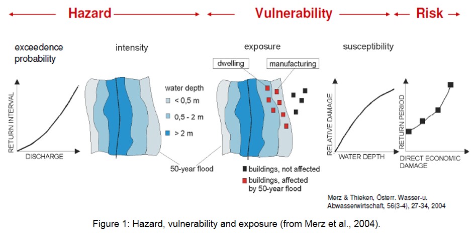
Flood hazard estimation usually requires (i) a statistical analysis of precipitation recorded at rain gauges, (ii) a hydrologic model transforming the precipitation into river discharge, (iii) a hydrodynamic model of the river and its surrounding floodplain areas. The results of this analysis are described in flood hazard maps in terms of several parameters of intensity
- • Inundation extent
- • Spatial distribution of flood depths
- • Spatial distribution of flow velocities
for a defined probabilistic scenario (see left hand side of Fig. 1). Several probabilistic scenarios must be analysed, from frequent to rare events.
Flood exposure analysis consists in the identification of the target objects lying inside the inundated area for any assigned inundation scenario. This step usually requires a spatial analysis of the target layer in a GIS environment where inundated area and objects can be intersected.
The analysis of flood vulnerability is the evaluation of the degree of damage or the susceptibility of the exposed target object, which is usually a function of the flood parameters (e.g. water depth and velocity). The most used approach for the assessment of vulnerability is the use of stage-damage curves, which relate a certain water depth to an expected degree of loss in relative or absolute terms. Thus again, flood hazard, i.e. water depth at a location for a given probability scenario, is the most crucial information to be evaluated.
The following sections describe how flood hazard is evaluated at different spatial scales.