

Hydrology
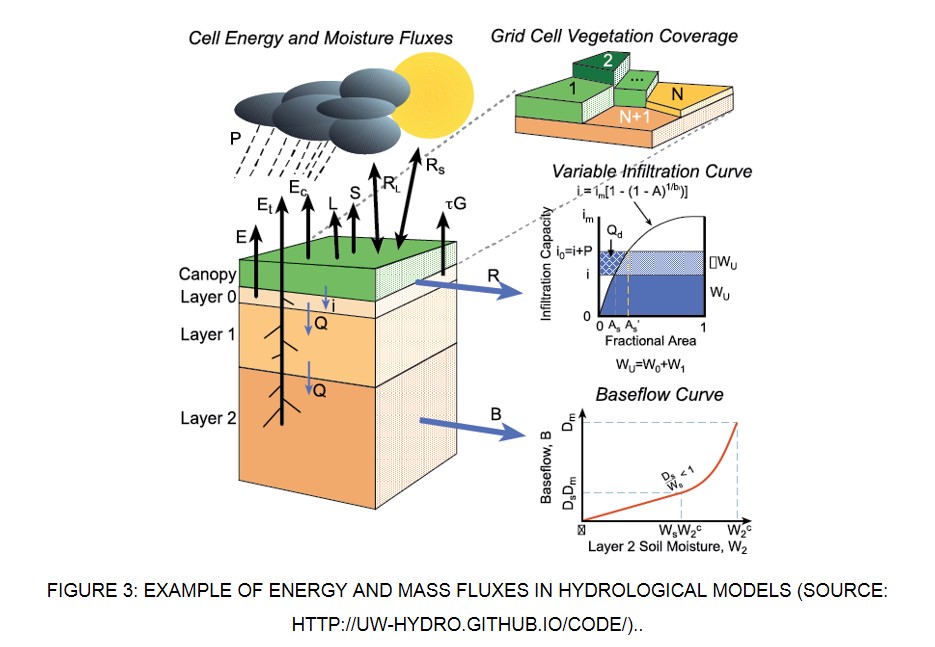
Hydrologic models, also known as rainfall-runoff models, transform rainfall into river discharge, based on physical exchanges between atmosphere, soil and streams. Rainfall-runoff models are classified based on model input and parameters and the extent of physical principles applied in the model. They can be classified as lumped and distributed models based on the model parameters as a function of space and time and deterministic and stochastic models based on the other criteria (Devi et al., 2015). Deterministic model will give same output for a single set of input values whereas in stochastic models, different values of output can be produced for a single set of inputs. According to Moradkhani and Sorooshian (2008) in lumped models, the entire river basin is taken as a single unit where spatial variability is disregarded and hence the outputs are generated without considering the spatial processes where as a distributed model can make predictions that are distributed in space by dividing the entire catchment in to small units, usually square cells or triangulated irregular network, so that the parameters, inputs and outputs can vary spatially.
Another classification is static and dynamic models based on time factor. Static model exclude time while dynamic model include time. Sorooshian et al. (2008) classified the models as event based and continuous models. The former one produce output only for specific time periods while the latter produces a continuous output. One of the most important classifications is between empirical model, conceptual models and physically based models.
Empirical models are observation oriented models which take only the information from the existing data without considering the features and processes of hydrological system and hence these models are also called data driven models. It involves mathematical equations derived from concurrent input and output time series and not from the physical processes of the catchment. These models are valid only within the boundaries. Unit hydrograph is an example of this method. Statistically based methods use regression and correlation models and are used to find the functional relationship between inputs and outputs.
State of art regional hydrologic modelling (Fluegel, 1995; Bloeschl and Sivapalan, 1995, Castelli, 1996; Arnold et al., 1998) are usually physically based and distributed and rely on crucial climatic and geographic information (obtained also by earth observation data and remote sensing) such as:
- • Historical rainfall (intensity, duration)
- • Orography and Digital terrain model
- • Land use-land cover
- • Soil properties (e.g. hydraulic conductivity, soil moisture)
Hazard assessment relies on the simulation of probabilistic rainfall event (even rare extremes) which are used as input data for hydrologic model to obtain a design hydrograph, i.e. a temporal representation of river discharge. The river discharge is used as boundary condition of hydraulic models (next section) to identify flood-prone areas.